High Carlingill Project
Dig 2022
Daily Blog
And Finally:

Over the course of the dig the intrepid diggers faced everything from risk of sunstroke to risk of frostbite. Some days the trenches needed pumping out. It was sometimes so wet that Bob tried fishing instead.
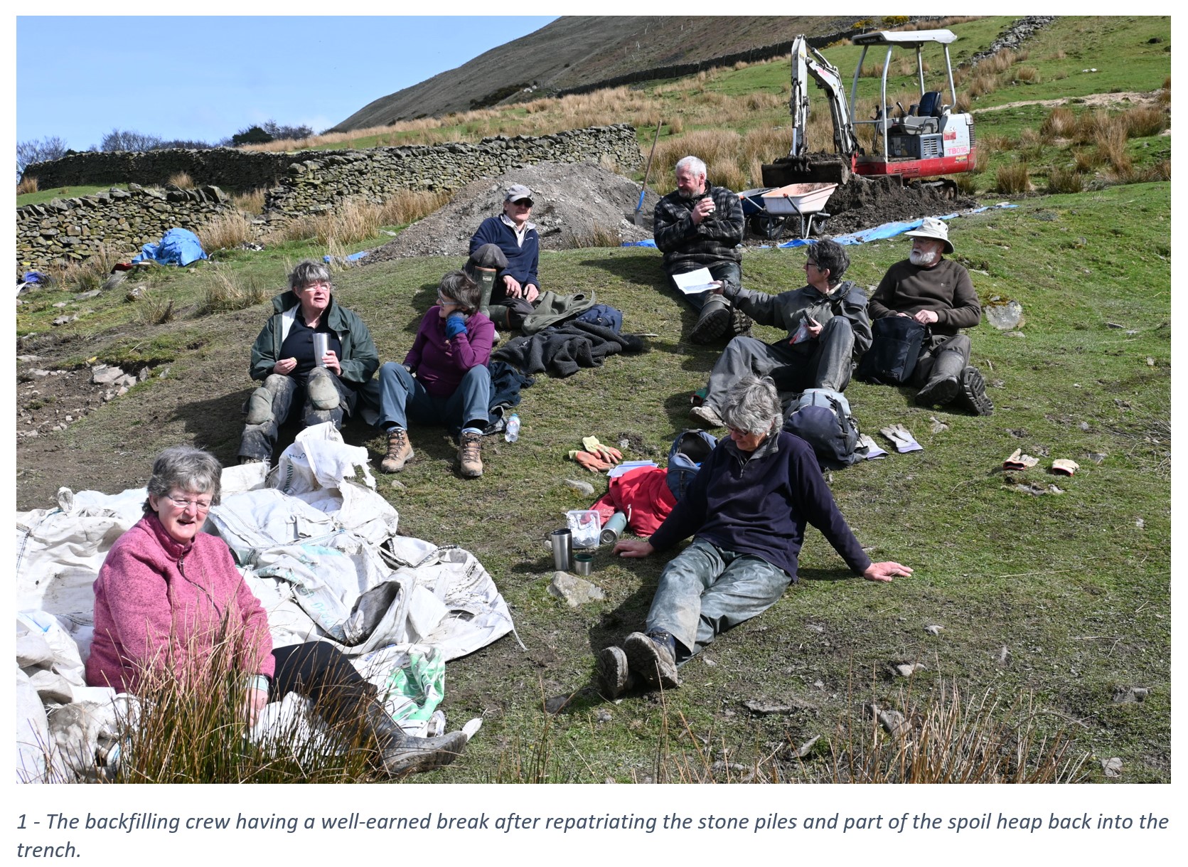
Day 16: Filling in.
Well didn’t all the diggers move a tremendous amount of earth and stones. It seemed that the spoil heap wouldn’t diminish in size when the numerous barrow loads of earth were being returned to the trench.
A Big Thank You to all the diggers who’s care, and effort allowed Jan and Bob to record their efforts and the revealed archaeology. Lastly thanks to: the crew that came to fill in the trench and return the land to the farmer, especially Alistair and hos digger, as well as to David Knipe who allowed us to undertake a further dig on his land.

Day 15: Saturday. Final dig day
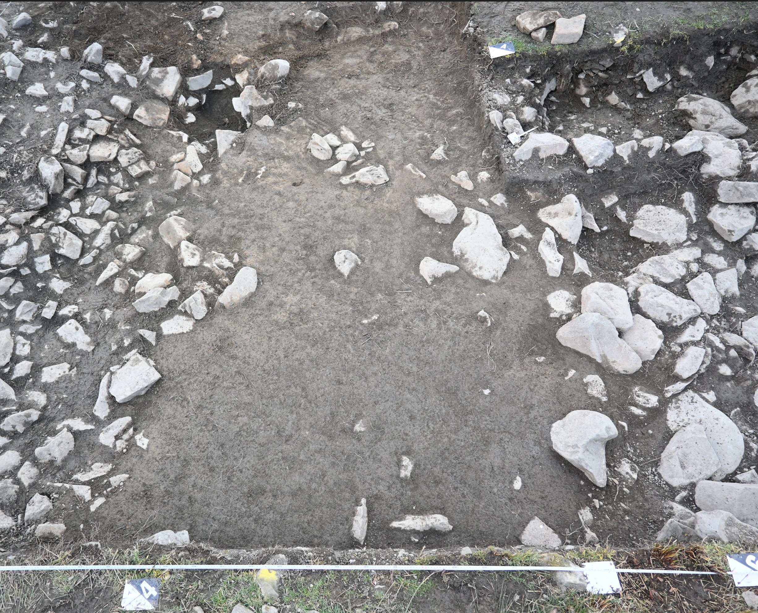
During Friday and Saturday we continued to try and resolve the site with sections through the revetment which revealed that it is both a well-built wall and helow as fill behind connecting it to the third cruder wall. A potentially Roman sandstone tile was recovered from within a small interior wall with charcoal beneath, and another from cleaning the trench edge. A thorough clean made the site presentable for a last set of photos before all the tags were removed and made ready for backfill on Sunday with the help of Alistair and his tractor/digger.
Until we have some analysis completed with dates returned and a little more research the typology of the site is a mystery. Note that we have uncovered: two significantly built parallel walls with a connecting curved wall linking them; a sill of flat flag stone inside the curved and straight walls; flagged, cobbled and clay floors; interior walls straight and curved. A stone lined and capped drain ducting surface water away from the structure (which still flows with water as witnessed on the very wet days of digging).
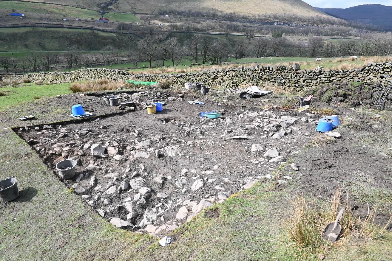
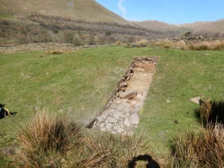
Now that the digging is over the pulling together of the recording begins. Below is a last look at the whole site.

The white tags on the grass outside the trench lower left and right show the line of the drain (using Dowsing).
Day 13: Thursday
After a wet wash out day on Wednesday and everyone retired early, but Jan manged to carry with some (soggy) plan drawing, we had to pump out the trench on Thursday morning before we could attempt to carry on. The weather in the morning was a little windy with rainy intervals. Diggers (Michelle, Linda, Alison & Andrew) helped with drawing section and plans. By lunch time the temperature dropped, with the wind chill the remaining diggers need to warm up with some digging. Following record photos being taken over the lunch break a section across the revetment was initiated. Perry continued in his mission to resolve the ground within the interior of the prospective roundhouse south-eastern wall (centre left in photo). By 2:30pm the rain had set in and we had to abandon further work for safety and practical reasons. We cleared site and by the time we left the rain had turned to sleet.
The weather forecast for the next few days seems to be drier but starting cold on Friday morning and warming up Saturday & Sunday. With the weather delays we will revert back to the original backfill day of Sunday 10th April.

Day 12:
Rain stopped play. The trench had turned into a brown swimming pool overnight.
Day 11:
Today was wet with a few spells of dryness. The valiant volunteer diggers slipped a slithered around with great gusto despite the weather and being encouraged to stop for sustenance breaks.
We were privileged to receive a visit from Yorkshire Dales National Park Archaeologist Dr Douglas Mitcham and Rebekah Booth, Cultural Heritage Trainee (YDNPA/WDLP). Doug expressed kind words of encouragement and was impressed by the archaeology revealed.
 The state of play at the end of the day with the rain beating effective & safe activities on site.
 LHS: The line of a prospective roundhouse can be seen here with inner and outer wall. RHS: Diligent trowelling has revealed a yellowish layer across most of the area bounded by the prospective roundhouse

The rain is coming from up there!

What rain? I love digging in the mud! What is going on here?
Day 10:
More excitement today with more uncovered contexts and 20’ish new finds including a
number of reasonably sized pieces of iron, more charcoal and a shard of Samian pottery in a
poor state of preservation.
The full complement of diggers kept Jan & Bob on their toes all day with the multiple finds –
the importance of paperwork.


Day 9:
A dry day and a little warmer for a while when the sun came out.
Numbers of diggers up today and more progress was being made although it may seem slow but
steady.
We hosted a visit Martin & Dot from Altogether Archaeology who were keen to see how the whole
site is being interpreted.
Today’s excitement – a stone lined/capped drain was found by Linda. This is uphill and to the east of
the prospective round house and later walls. Using dowsing rods this drain seems to link in with that
found last year in the last Solstice excavation.


Day 8:
The weather was dry and a little warmer today (+3 degrees). The number of diggers was only two
plus Jan & Bob so progress was a little slower today and subsequently the report for today is short.
We had the spectacle of watching a steam train pulling a set of Pulman coaches traveling North
around midday.


Day 7, Friday 1st April 2022:
Despite it being 1st April we didn’t find a chariot burial under a stone or two. The clay floor found in day 6 has turned out to be well constructed and approximately 10cm deep. A sondage cut through the clay floor has revealed flat slab stones inline with the prospective round house wall on the western side of the trench. No magical finds today except for some charcoal. Weather was a degree warmer than Thursday, drier, but a lazy wind still caught ones breath when standing up. Had a more detailed drone survey undertaken by our friend Mark Simpson
Apparent line of Roundhouse wall on western side of trench with more foundation stones found below the clay floor has revealed flat slab stones inline with the prospective round house wall on the western side of the trench.
No magical finds today except for some charcoal.
Weather was a degree warmer than Thursday, drier, but a lazy wind still caught ones breath when standing up.


Day 6:
The site being covered with snow upon arrival required as brush down to remove it before we could continue the excavation. Temperatures were around 0 degrees Celsius and the wind meant that it felt colder still. Later in the day we had short spells of sunshine which were greatly welcomed finishing the day off with a flurry of hailstones.
 Keeping low down reduced the effect of the wind – the diggers enjoying a moment in the sun.
Was the circular pit that was capped with a red flatish stone mentioned in day 4’s report an infilled post hole? This and the one mentioned above are approximately parallel to the NW-SE wall.


LH photo : Area believed to be a post hole with a post pad at the base
RH photo : Removed post pad.
 A clay floor running NW-SE that apparently cuts across the line of a circular wall – perhaps connected with a later structure. This clay floor is carefully being removed – during which a small fragment of blueish glass (possibly roman) has been found. (The clay floor being level is reminiscent of those observed in the Maryport Vicus excavations)

Note that it would seem that on the uphill side (east) of the circular structure the outer wall is not defined and contains stone cobbles filling the space up the slope of the hill. This has been observed on the other excavated round houses on the High Carlingill site.
Day 5:
The author not being on site on Wednesday, but work continued to resolve the site under Jan’s direction and a small fragment of Samian ware (Roman from potteries in Gaul) was found.
Day 4:
Today’s diggers defined a wall continuing from the trench dug last year, which appears to sit on the roundhouse, at last in part. We need to clean back further to see if this roundhouse still exists in this area.
The exciting pit contained large stones, packed hard, ina clay-rich matrix The pit itsekf appeared to have a clay lining, We kept the fil for possible environmental analysis, but it looks pretty sterile. So we have no idea what the pit was for – probably storage.
The trench at midday in much better weather
Half of the pit excavated showing fill stones

The whole pit excavated

Day 3:
This year’s dig is looking at the rest of the top of the mound that we excavated last year.
We had 2 scorching hot days for deturfing and removing topsoil, which left us with the usual incoherent spread of stone. Grateful thanks are due to the stalwarts who turned up this morning in less than good weather, and who worked all day in constant rain. Parts of the trench were abandoned as being too wet and muddy to get on, but we cleared a lot of stone and think we have defined a large part of the line of the roundhouse that we uncovered at the end of the last dig. There are also a couple of other probable walls which need defining, and a rectangular area on the edge of the trench which held water very well, and may have a clay floor or similar beneath it.
Finds so far are a few bits of charcoal, a couple of nails and three interesting pieces of worked stone
The prize exhibit, however, goes to the very large subcircular piece of sandstone, located inside the roundhouse area, which when lifted, right at the end of the day, proved to be covering a pit. Tomorrow will be exciting!!
LAS High Carlingill Excavation HCE22 Day 3 28th March 2022
The digging crew having a well earned break whilst photogrammetry photos were being taken.

The excavated site after lunch with Jan giving our spot interpretation of what has been uncovered so far.

The site as excavated by midday looking south

Note that this red sandstone seemed to be resting on about four red sandstone angular cobbles. The stone removed revealing what seems to be a pit – it is a cap stone.

The next step is to carefully section the pit retaining all excavated material.

Jan & Bob – joint dig directors 28th March 2022
Digging for Britons!
Community excavations in the Lune Gorge
End of Project Reflections
The Digging for Britons project is now nearly over. We would like to express a HUGE thanks to the National Lottery Heritage Fund for supporting the project over the last three years – and especially to the players of the National Lottery without whom the project would not have been possible.
The project achieved a number of objectives:
- First and foremost we believe we have made a useful contribution to knowledge about the native population at the time of the Roman occupation. The reports below (which are downloadable) detail the findings. In summary the settlement at High Carlingill was established sometime in the first or second centuries BC, was occupied throughout the Roman period, and was re-occupied in the early medieval period. Pottery finds suggest the natives were trading with the Roman occupiers of the fort at Low Borrowbridge, probably providing the fort with food supplies of meat and grain. The evidence points to peaceful co-existence rather than direct conflict.
- Over 50 volunteers have been trained in archaeological techniques and approaches which we hope will enable them to contribute to future projects and, indeed, lead their own excavations:
- 21 volunteers attended a workshop on identifying and analysing ceramic finds led by Christine Howard-Davies of Oxford Archaeology
- 14 volunteers were trained in field walk-over survey techniques by Dan Ellsworth of Greenlane Archaeology
- 9 volunteers attended the post-excavation laboratories at Durham University to see firsthand how post-ex is handled prior to paleoenvironmental analysis and radio carbon dating
- 18 young archaeologists from the Young Archaeologists Club (YACs) of Hawes and Kendal participated in digs under the direction of Solstice Heritage
- 12 Yorkshire Dales Young Rangers undertook a day of excavation under the supervision of Solstice Heritage
- 40 primary school children from Orton CE Primary School were able to dig under supervision
- 50 adult volunteers worked for between one and 30 days each on the excavations, at total of around 300 volunteer days
- The Yorkshire Dales National Park archaeologists have now approved LAS as a trained organisation able to direct its own excavations without further supervision
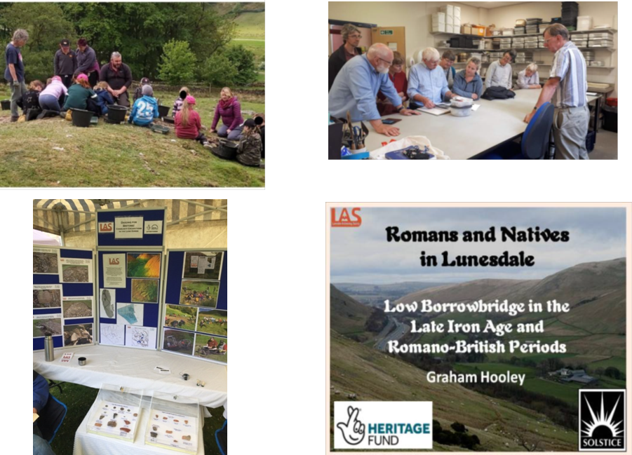
- We were particularly keen to engage the local communities to stimulate a greater appreciation of their local heritage. Through articles in local newspapers and newsletters we were able to reach a wider local population. In addition displays were mounted at local markets and events, and talks were delivered in person or via Zoom to members of local history and archaeology societies. Several regional history and archaeology groups came to visit during the project and were shown round the excavations. News items on local television helped raise general awareness, and an article for the annual Transactions of the Cumberland and Westmorland Archaeological and Antiquarian Society (downloadable below) brought our findings to a more specialist audience.
- A 32 page booklet outlining findings for a general audience was produced and distributed among local schools, societies and at local events. A second 16 page booklet aimed at school children was designed to stimulate their interest in archaeology and heritage. Both are downloadable from this website.
- During the project we have been pleased to be able to support local businesses, especially during the pandemic. Where possible we have placed contracts with local firms, such as Solstice Heritage, Cerberus Printing and Cumbria Loos, while also supporting the farm at High Carlingill.
THANK YOU!
To all the volunteers and participants on the dig
We hope to be able to work with you again soon!
The project as it happened:
Geophysics and Walkover survey
The ‘Digging for Britons’ project started in June with an aerial survey using a UAV to create a detailed photogrammetric plan of the site and a magnetometry survey by SUMO, the archaeology firm specialising in these techniques. This was followed by a walkover survey in July. The results from these were used to identify targets for the September/October excavations.
The full 59 page report on these surveys is available for download: SUMO Report High Carlingill_FINAL
Pictures show the UAV (unmanned aerial vehicle) prior to take off, the geophys team setting off, and the many ‘lumps and bumps’ in the field.


Pictures from the walkover survey, where volunteers received training in survey techniques

Briefing for the survey

Surveying the features
Dig 2018
The interim report for the first dig in 2018 is now available. Click the following link to download the PDF. Digging for Britons, High Carlingill, Cumbria – 2018 Excavation Interim Report v1.1 (Lo-Res).
There were some very interesting results from the C14 dating. giving dates spanning from before to after the Roman period, suggesting that the site was occupied for many hundreds of years.
Dig 2019
The 2019 dig has been completed. The weather was mainly fine and we rapidly came down on flag floors in two circular structures in different areas of the site. There were quite a lot of pottery finds and hopefully abundant opportunities for C14 dating from the many soil samples taken from different contexts. We have now received the palaeoenvironmental analysis from the dig earlier this year at High Carlingill. The report shows the use of spelt wheat and barley (typical of Iron Age sites in the North) along with samples of material that could have been used for fodder, bedding and/or thatch. We have eight good samples from four different contexts suitable for dating and these have now been sent for analysis. Click here to download the PDF: Palaeo assess 2019 pdf
In the meantime members may be interested to hear that we have a poster accepted for a conference at Tullie House in Carlisle on Northern Pre-History that will take place 12-13 October (see Tullie House website for details if you wish to attend). Click here for a copy of the abstract: Northern Prehistory Conference – High Carlingill Abstract
We have now received the report from Solstice for the 2018 and 2019 digs. You can download the PDF here: Digging for Britons, High Carlingill, Cumbria – 2018-2019 Excavation Report
Jan has produced a summary of the digs for the general public. A copy can be downloaded here: High Carlingill booklet
Booklet produced by LAS and The Yorkshire Dales Young Archaeologists Club : YAC booklet
We have had an article accepted for the annual Transactions of the Cumberland and Westmorland Archaeological and Antiquarian Society: High Carlingill Paper
Dig 2021
High Carlingill final excavation May 2021
The final 4 days of excavation at High Carlingill was undertaken early in May 2021 by Solstice Heritage. Unfortunately the constraints of the pandemic made it impossible for teams of volunteers to be on site.

Two trenches were excavated, trench 8 through feature IX, and trench 7 through feature IV.
The former was chosen as a distinct flat platform, cut into the hill but not into the bank surrounding the enclosure. It was hoped that this would prove to be a roundhouse, possibly earlier in date than those previously excavated, and that dating material would be recovered. Feature IV is an isolated mound, close to a track which was investigated in 2019 and which is thought to be later than the native settlement. The mound was thought to be a possible dump of quarry waste overlying earlier features.
Trench 8
Trench 8 was cut through the approximate centre of the platform, in the hope of locating a hearth. It did not reveal the hoped-for roundhouse. A spread of rubble failed to resolve into a recognisable floor surface, and it appeared that if there had been a roundhouse there it had been eroded away and slipped down the hillside. However a small extension of the trench towards the back of the platform did reveal a small section of coursed stonework, which showed very similar features to the walls of the previously excavated structures. This was interpreted as the remains of the back wall of the derelict structure. There were no finds and no dateable material was recovered.

Trench 7
Trench 7 was cut into the side of the mound from the base. A large amount of loose rubble was removed, but it soon became obvious that this was not a dump of quarry waste. The mound had been built with a levelling layer of gravel and the base was revetted with large boulders, reminiscent of those found on the enclosure banks. At the base of the mound and extending out from it was an area of paving. It was concluded that there is probably a roundhouse on this mound, and demonstrates how some of the other platforms may have been constructed.
When two of the paving slabs were lifted, a well constructed drain was revealed running downslope in front of the mound. This contained a quantity of wet organic matter, which was retrieved and will hopefully yield material suitable for dating.

This is a very brief summary of the work. The full report is downloadable here: Digging for Britons, High Carlingill, Cumbria – 2021 Excavation Report v2.0
Final excavation June/July 2021
Following the revelations of Trench 7 excavated by Solstice in May (High Carlingill 2021), we decided to further investigate mound IV (see plan below) to see if there was a roundhouse on top.
The excavation took the form of a single trench covering the SW quadrant of the top of the mound, linking up with previous Trench 7.

Removal of turf and topsoil revealed a spread of stone, with an area of heavily compacted soil running through it. Initially this was thought to be a possible floor surface. However, it was very close to the surface, and its location immediately beneath an area of silage plastic and waste suggested that the compaction arose from large round bales of silage being put on the mound as winter feed for the livestock. Removal of this feature gave an equal spread of stone across the site.
After removal of stone tumble in the area an area in the northern corner of the trench had little stone, and as it was cleaned back appeared to be a compacted clay surface. Initially thought to be a hearth, no evidence of burning was found and it remains of unknown function. However, close to it several pieces of badly corroded iron were retrieved, and at least one appears to be part of a blade.
Extending south from the clay surface the tumbled stones became less angular and flatter as they extended down the slope. The stones stopped short of the SW corner, and the surface became much less compact than the topsoil, containing a lot of small stones.
Removal of more loose limestone revealed a layer of flat limestone flags on the NW side of the trench beside which was a linear area containing less stone in general, but a lot of shattered red sandstone. This adjoined another area of large limestone flags contained a depression showing evidence of burning, with discoloured stones and a high proportion of shattered red sandstone. The fill removed from this depression was rich in charcoal and considered to be a possible fire pit. There was also a large piece of partly burnt wood, approx. 6 x 3 ins, although it broke up during lifting. An edge adjacent to the south side of the fire area suggested the location of a wall, running straight across the trench, approximately N-S. A possible wall edge as also seen running E-W along the edge of the mound, above the trench originally opened in April. This suggested the existence of a rectangular structure on top of the mound, associated with a floor and fire pit or hearth. Removal of more surface stone confirmed the existence of these walls. That running N–S was considerably better built, particularly at the northern end. The lower stones showed signs of heat damage, showing that the wall was in place at the time the fire was in use.

A small second charcoal-rich area was found on the flags at the N edge of the trench. Neaby were four corroded pieces of metal, at least one of which seems to be a blade.
A depression in the SW edge of the trench was associated with a hollow running down the mound to the ground surface below. A sondage was placed over half of this depression to determine whether this might be an entrance. Removal of the surface stone revealed a layer of gravelly soil beneath which was a well made cobbled surface. The rest of the trench west of the possible N-S wall was excavated to this layer, and the cobbled surface was revealed in the whole area. The trench was also extended down into the hollow and the cobbles were encountered in the whole area. Ths is in contrast to the trench excavated in April, which showed deposits of gravelly soil, large stones as revetments at top and base, and a yellow sandy layer across the trench. This supports the suggestion that the hollow winding up the mound is a made up access track.
The flagstones covered only about 50% of the area behind the wall; the northern end was the same gravelly soil as seen overlying the cobbles. Removal of this gravel revealed a yellowish clay, believed to be the natural postglacial deposit. The flagstones were set directly on to this clay.
Cleaning back the E-W wall failed to find a good edge but did yield a large piece of samian mortarium. More large limestone flag-type stones were revealed. These seemed to form an edge, and many of them were not as flat as would be expected. Further removal of gravel and surface stones revealed a second line of large limestone slabs, running parallel to and butting up against th e first. The line appeared slightly curved.

A sondage through the N-S was showed that its northern end overlay the curving flat slabs. The cobbles ended at this line. It was concluded that the slabs were likely to be a foundation for an early building, possibly a roundhouse, and that a poorly constructed rectangular building had been erected on the site after it had gone out of use, probably using the stones from the original building.
Large deposits of big pieces of charcoal were found in several places within the gravel layer and between the flagstones, but not on top of the flags. There were also extensive scatters of small pieces of charcoal. We suggest that one of the buildings may have burnt down.
Three charcoal samples, including the large piece of burnt wood, and the fill from the fire pit are being sent to Durham for analysis. Hopefully we will get some interesting dates. We would like to thank CWAAS for funding the laboratory investigations
